


COORDINATES / KOORDINAT
2.467329° N; 102.231026° E (2° 28' 2.3838" N; 102° 13' 51.693" E)
LOCATION
Tampin is the name of a town and a district at the border of two states – Negeri Sembilan and Melaka (Tampin, 2013). Tampin Mountain, where the Titiwangsa Range – the longest mountain range in Peninsular Malaysia – begins, is in the district of Tampin.
LOKASI
Tampin adalah nama sebuah bandar dan nama daerah di sempadan dua buah negeri, iaitu Negeri Sembilan dan Melaka. (Tampin, 2013). Gunung Tampin yang merupakan tempat bermulanya Banjaran Titiwangsa – banjaran gunung yang terpanjang di Semenanjung Malaysia – terletak dalam daerah Tampin.
TOPONYMY
Tampin is named after a container that is weaved from pandan leaves. This container is used to store food such as “dodol” (the famous Melaka sticky sweets made from coconut milk, red sugar and glutinous rice) and “belacan” (shrimp paste) (Tampin, 2014).
TOPONOMI
Tampin mendapat namanya dari bekas yang ditenun dari pelepah pandan. Bekas ini digunakan untuk menyimpan makanan seperti dodol dan belacan (Tampin, 2014).
ATTRACTION
- Taman Tasik Tampin
- Gunung Tampin
TARIKAN
- Taman Tasik Tampin
- Tampin Mountain
REFERENCE
http://jamilhaji53.blogspot.com/2013/09/asal-nama-siliau.html (SILIAU, Rantau) Jelebu. (2014). Retrieved at August 24, 2014 from http://ms.wikipedia.org/wiki/Jelebu

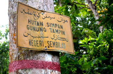
Sempadan Melaka-Negeri Sembilan di Pekan Tampin
The Melaka-Negeri Sembilan Border in Tampin Town
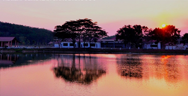
 Taman Tasik Tampin
Tampin Lake Garden
 Gunung Tampin tempat bermulanya
 Banjaran Titiwangsa di selatan (Tampin)
Mount Tampin - Where the Titiwangsa Range begins


 |
| SILIAU |
 |
| Rantau is located approximately 28.3km to the South-West of Seremban via Route 53 and 18.5km to the North-East of Port Dickson via Route 53 and N6. It is situated in Rantau, a plantation area which is represented by the current Menteri Besar of Negeri Sembilan, Dato’ Seri Utama Haji Mohamad bin Haji Hasan... |
 |
| REMBAU |
 |
| Rembau is a town within a district that shares the same name (i.e. Rembau). It is located in the state of Negeri Sembilan. The district is a stronghold of the matrilineal system known as “adat perpatih”, a customary practice inherited from the people of Minangkabau in Sumatera. Politically, the district is the Parliament... |
| About | |
| • The Project | |
| • Objective | |
| • Mission | |
| • Partners | |
| Hightlights | |
| • Batak Rabit, Perak | |
| • Desa Temu Jodoh | |
| • Lembah Bujang, Kedah | |
| • Kajang, Selangor | |
| Contacts | |
| info@ukm.com.my | |
| T : +603 8922 8989 | |
| F : +603 8922 8988 | |